Inscription
Built in 1782
This log cabin, typical of the log cabins built by the first white settlers, is one of the very few original log cabins in Allegheny County. It was in cabins such as this that our forefathers established their hold on the soil and raised the first family of pioneer children.This cabin has been rebuilt to the exact original size, using eight of the original logs and the original rafters. It has the appearance of the original cabin which stood on the same location, but twelve feet lower. When the property was acquired by Jefferson Memorial Park in 1929 the cabin was then in a deep gully, near a beautiful, never-failing spring located a few feet away, coming from beneath the roots of a giant white oak tree which sheltered from spying Indian eyes not only the spring, which has now become a well, but also the cabin.
Jacob Beam originally staked out his claim to the tract of 160 acres of land and built this cabin in 1782. The tract was surveyed pursuant to a warrant to Jacob Beam dated February 10th, 1785, and on January 6th, 1798, was deeded to to him by the Commonwealth of Pennsylvania under the authority of Thomas Mifflin, Pennsylvania's first governor. (deed may be viewed in administration building)
Jacob Beam had another tract of land a few miles east of this one and about 1800 he sold this tract to Aaron Work, whose descendants held the property until it was acquired in 1929 by Harry C. Neel, a great-great-grandson of Aaron, and founder of Jefferson Memorial Park.
Details
| HM Number | HM1HMD |
|---|---|
| Tags | |
| Marker Condition | No reports yet |
| Date Added | Sunday, November 2nd, 2014 at 11:15pm PST -08:00 |
Pictures
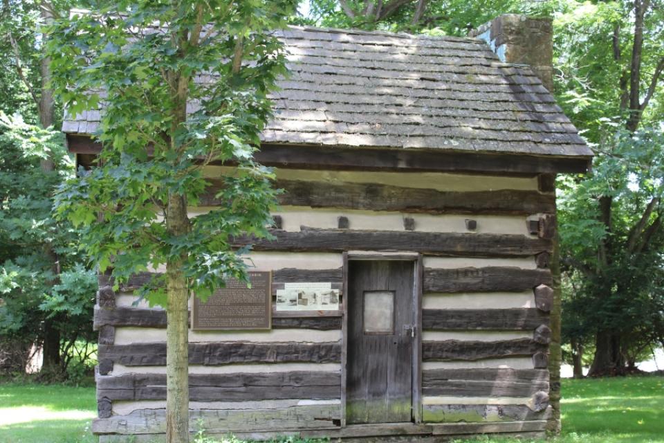
Photo Credits: [1] SWALTERS
Locationbig map
| UTM (WGS84 Datum) | 17T E 586993 N 4465213 |
|---|---|
| Decimal Degrees | 40.33293333, -79.97588333 |
| Degrees and Decimal Minutes | N 40° 19.976', W 79° 58.553' |
| Degrees, Minutes and Seconds | 40° 19' 58.56" N, 79° 58' 33.18" W |
| Driving Directions | Google Maps |
| Area Code(s) | 412, 724 |
| Closest Postal Address | At or near 355 Old Curry Hollow Rd, Pleasant Hills PA 15236, US |
| Alternative Maps | Google Maps, MapQuest, Bing Maps, Yahoo Maps, MSR Maps, OpenCycleMap, MyTopo Maps, OpenStreetMap |
Is this marker missing? Are the coordinates wrong? Do you have additional information that you would like to share with us? If so, check in.
Nearby Markersshow on map
Show me all markers in: Pleasant Hills, PA | Allegheny County | 15236 | Pennsylvania | United States of America
Maintenance Issues
- Is this marker part of a series?
- What historical period does the marker represent?
- What historical place does the marker represent?
- What type of marker is it?
- What class is the marker?
- What style is the marker?
- Does the marker have a number?
- What year was the marker erected?
- Who or what organization placed the marker?
- This marker could use another picture or two.
- Can this marker be seen from the road?
- Is the marker in the median?
Comments 0 comments