Inscription
The first County Seat of Telfair County, Jacksonville, was named for General Andrew Jackson and incorporated in 1815. In the early 19th century, a courthouse was erected near the site of the present Methodist Church. Jacksonville was an important point on the Blackshear Trail which followed the Altamaha and Ocmulgee rivers from Darien to Fort Hawkins. One of the county's three blockhouses was built nearby by General David Blackshear as a refuge and a house of thanksgiving. The center of a large and wealthy plantation economy, Jacksonville was a landing for freight and passenger traffic on the river before and for some years after the Civil War. In 1871, McRae became the County Seat. Among the distinguished early settlers of Jacksonville were General John E. Coffee, soldier, pioneer surveyor, member of Congress, and General Mark Willcox, a state legislator and soldier in the Indian Wars. Each of these men has a county in Georgia named for him. Other pioneer residents included the McRae, Clements, Hatton, and Pridgen families.
Re-erected by the Georgia Historical Society and the Pioneer Historical Society in 2017
Re-erected by the Georgia Historical Society and the Pioneer Historical Society in 2017
Details
| HM Number | HM69P |
|---|---|
| Series | This marker is part of the Georgia: Georgia Historical Society/Commission series |
| Tags | |
| Historical Period | Civil War, 19th Century |
| Historical Place | Town, Residential Community |
| Marker Type | Other |
| Marker Class | Historical Marker |
| Marker Style | Interpretative Marker / Sign |
| Marker Number | 134-3 |
| Year Placed | 2017 |
| Placed By | Georgia Historical Society and the Pioneer Historical Society |
| Marker Condition | No reports yet |
| Date Added | Saturday, September 27th, 2014 at 10:25am PDT -07:00 |
Pictures
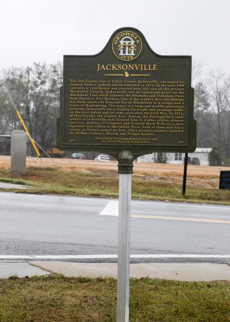
Photo Credits: [1] GEORGIAHISTORY.COM
Locationbig map
| UTM (WGS84 Datum) | 17R E 312657 N 3521344 |
|---|---|
| Decimal Degrees | 31.81236667, -82.97920000 |
| Degrees and Decimal Minutes | N 31° 48.742', W 82° 58.752' |
| Degrees, Minutes and Seconds | 31° 48' 44.5200" N, 82° 58' 45.1200" W |
| Driving Directions | Google Maps |
| Area Code(s) | 229 |
| Can be seen from road? | Yes |
| Is marker in the median? | Yes |
| Closest Postal Address | At or near 3694 US-441, Jacksonville GA 31544, US |
| Alternative Maps | Google Maps, MapQuest, Bing Maps, Yahoo Maps, MSR Maps, OpenCycleMap, MyTopo Maps, OpenStreetMap |
Is this marker missing? Are the coordinates wrong? Do you have additional information that you would like to share with us? If so, check in.
Nearby Markersshow on map
Show me all markers in: Jacksonville, GA | Telfair County | 31544 | Georgia | United States of America
Maintenance Issues
- This marker could use another picture or two.
Comments 0 comments