Inscription
Throughout the 19th Century, lumbering on the Susquehanna River was a major industry. Logs were cut from the forests in the northern part of the state and floated down river to sawmills at Harrisburg and points further south. a popular place where the loggers stopped to recreate was the "Hardscrabble" neighborhood, located between Herr and Calder Streets on the west side of Front Street. Here thrived boat liveries and related businesses catering to the river trade. However, with the decline of logging by the turn of the Century, and the subsequent public outcry that worsening sanitary conditions along the riverfront be addressed, Hardscrabble's days were numbered. The resulting plan developed by the Harrisburg League of municipal Improvements, one of the first and most comprehensive civic-improvement initiatives in the United States, involved the northward expansion of Riverfront Park, the construction of the famous river steps and as one of the last components of this initiative, the demolition of old Hardscrabble in 1924 for the development of the beautiful Sunken Gardens. Although incorporated into the park, some of the basement grade levels of the old houses were retained and not filled to provide for a unique garden plan, formal and symmetrical in design, which has since offered a stunning and unparalleled vantage point to view the Susquehanna River, its islands and mountains beyond.
Top Photo
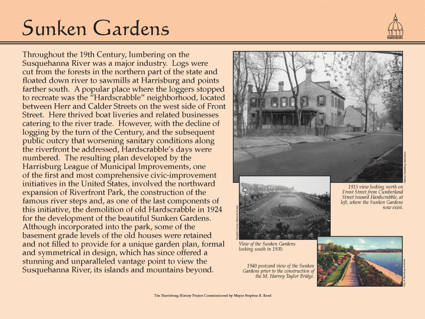
1915 view looking north on Front Street from Cumberland Street toward Hardscrabble, at left, where the Sunken Gardens now exist.
Middle Photo
View of the Sunken Gardens looking south in 1930.
Bottom Photo
1940 postcard view of the Sunken Gardens prior to the Construction of the M. Harvey Taylor Bridge.
Top Photo
1915 view looking north on Front Street from Cumberland Street toward Hardscrabble, at left, where the Sunken Gardens now exist.
Middle Photo
View of the Sunken Gardens looking south in 1930.
Bottom Photo
1940 postcard view of the Sunken Gardens prior to the Construction of the M. Harvey Taylor Bridge.
Details
| HM Number | HM3PP |
|---|---|
| Series | This marker is part of the Pennsylvania: The Harrisburg History Project series |
| Tags | |
| Placed By | The Harrisburg History Project Commissioned by Mayor Stephen R. Reed |
| Marker Condition | No reports yet |
| Date Added | Sunday, September 21st, 2014 at 6:02am PDT -07:00 |
Pictures
Locationbig map
| UTM (WGS84 Datum) | 18T E 339114 N 4459111 |
|---|---|
| Decimal Degrees | 40.26701667, -76.89213333 |
| Degrees and Decimal Minutes | N 40° 16.021', W 76° 53.528' |
| Degrees, Minutes and Seconds | 40° 16' 1.26" N, 76° 53' 31.68" W |
| Driving Directions | Google Maps |
| Area Code(s) | 717 |
| Closest Postal Address | At or near 1201 Capital Area Greenbelt, Harrisburg PA 17102, US |
| Alternative Maps | Google Maps, MapQuest, Bing Maps, Yahoo Maps, MSR Maps, OpenCycleMap, MyTopo Maps, OpenStreetMap |
Is this marker missing? Are the coordinates wrong? Do you have additional information that you would like to share with us? If so, check in.
Nearby Markersshow on map
Maintenance Issues
- What historical period does the marker represent?
- What historical place does the marker represent?
- What type of marker is it?
- What class is the marker?
- What style is the marker?
- Does the marker have a number?
- What year was the marker erected?
- This marker could use another picture or two.
- Can this marker be seen from the road?
- Is the marker in the median?
Comments 0 comments