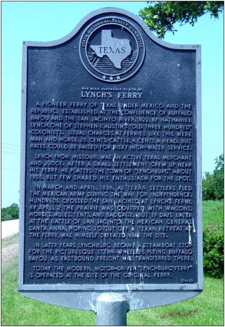
Inscription
The Lynchburg Town Ferry, founded in 1822 by Nathaniel Lynch, crosses the Houston Ship Channel downstream of the confluence of the San Jacinto River and Buffalo Bayou. In 1829, the authorities at San Felipe de Austin requested that Lynch move his ferry service, which had been running from Crystal Bay, upstream to a peninsula formed by a meander of the San Jacinto River. He satisfied the requirements in 1830, moving to an area near the present landing. Lynch passed away in 1837, but his family continued to operate the ferry service until 1848.
Between 1848 and 1888, various operators bought and ran the service. During this time, Lynchburg experienced many changes. A fire in 1874 and a series of storms dating from the late 1800s to the early 20th century devastated the town and hastened its decline.
In 1888, Harris County purchased the ferry and in 1920 put the diesel-powered, cable-free Chester H. Bryan boat into service. They added the Tex Dreyfus in 1945. The two boats were replaced in 1964 by the William P. Hobby and the Ross S. Sterling, which have served the area for a number of years.
By the 1950s, business returned to Lynchburg; a shipyard, marine service companies and the Coastal Water Authority all opened in following years. Today, the ferry continues to serve Harris County residents who work at the Port of Houston and at petrochemical plants along the ship channel. It remains an important economic contributor to the area, promoting tourism and helping to maintain Lynchburg as a focus of industry on the Houston Ship Channel.
Details
| HM Number | HM106Z |
|---|---|
| Tags | |
| Marker Number | 13677 |
| Year Placed | 2006 |
| Placed By | Texas Historical Commission |
| Marker Condition | No reports yet |
| Date Added | Wednesday, October 22nd, 2014 at 10:21am PDT -07:00 |
Pictures
Locationbig map
| UTM (WGS84 Datum) | 15R E 299161 N 3294564 |
|---|---|
| Decimal Degrees | 29.76510000, -95.07725000 |
| Degrees and Decimal Minutes | N 29° 45.906', W 95° 4.635' |
| Degrees, Minutes and Seconds | 29° 45' 54.36" N, 95° 4' 38.10" W |
| Driving Directions | Google Maps |
| Area Code(s) | 830, 281, 832 |
| Closest Postal Address | At or near 800 Independence Pkwy N, Baytown TX 77520, US |
| Alternative Maps | Google Maps, MapQuest, Bing Maps, Yahoo Maps, MSR Maps, OpenCycleMap, MyTopo Maps, OpenStreetMap |
Is this marker missing? Are the coordinates wrong? Do you have additional information that you would like to share with us? If so, check in.
Nearby Markersshow on map
Maintenance Issues
- Is this marker part of a series?
- What historical period does the marker represent?
- What historical place does the marker represent?
- What type of marker is it?
- What class is the marker?
- What style is the marker?
- This marker could use another picture or two.
- Can this marker be seen from the road?
- Is the marker in the median?
Comments 0 comments