Inscription
Like the Native Americans before them, European settlers used this rising ground or "hummock" on the shore of the Delaware Bay as a place for fishing and recreation. In 1738, Jehu Curtis received a patent for lands that he called "Kitt's Hammock." By the early 1800s, the Pleasanton family had established a tavern here for the entertainment of visitors. Around 1846, a hotel was built nearby. Known for a time as the Bay View Hotel, it was long the center of local activities. In the latter decades of the 19th century, a number of small cottages were erected here. Many were owned by residents of Dover who left the sweltering heat of summer behind for the cooling effects of the waters and bay breezes. Kitts Hummock continues to provide a peaceful refuge for residents and visitors alike.
Details
| HM Number | HMQGJ |
|---|---|
| Tags | |
| Marker Number | KC-80 |
| Year Placed | 2003 |
| Placed By | Delaware Public Archives |
| Marker Condition | No reports yet |
| Date Added | Friday, October 3rd, 2014 at 9:39pm PDT -07:00 |
Pictures
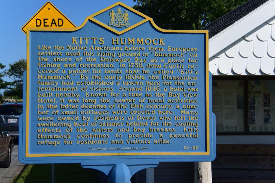
Photo Credits: [1] BRIDGER1963
Locationbig map
| UTM (WGS84 Datum) | 18S E 465221 N 4328239 |
|---|---|
| Decimal Degrees | 39.10260000, -75.40221667 |
| Degrees and Decimal Minutes | N 39° 6.156', W 75° 24.133' |
| Degrees, Minutes and Seconds | 39° 6' 9.36" N, 75° 24' 7.98" W |
| Driving Directions | Google Maps |
| Area Code(s) | 302 |
| Closest Postal Address | At or near 3076 Kitts Hummock Rd, Dover DE 19901, US |
| Alternative Maps | Google Maps, MapQuest, Bing Maps, Yahoo Maps, MSR Maps, OpenCycleMap, MyTopo Maps, OpenStreetMap |
Is this marker missing? Are the coordinates wrong? Do you have additional information that you would like to share with us? If so, check in.
Maintenance Issues
- Is this marker part of a series?
- What historical period does the marker represent?
- What historical place does the marker represent?
- What type of marker is it?
- What class is the marker?
- What style is the marker?
- This marker could use another picture or two.
- Can this marker be seen from the road?
- Is the marker in the median?
Comments 0 comments