Inscription
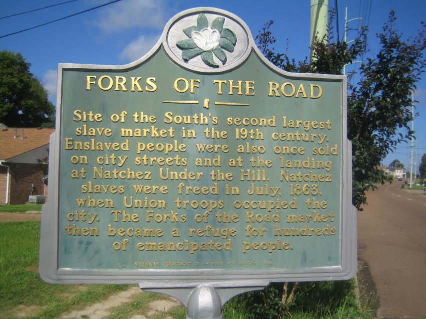
Site of the South's second largest slave market in the 19th century. Enslaved people were also once sold on city streets and at the landing at Natchez Under the Hill. Natchez slaves were freed in July, 1863, when Union troops occupied the city. The Forks of the Road market then became a refuge for hundreds of emancipated people.
Details
| HM Number | HMP15 |
|---|---|
| Tags | |
| Year Placed | 1998 |
| Placed By | Mississippi Department of Archives and History |
| Marker Condition | No reports yet |
| Date Added | Wednesday, October 22nd, 2014 at 5:27am PDT -07:00 |
Pictures
Locationbig map
| UTM (WGS84 Datum) | 15R E 653302 N 3492359 |
|---|---|
| Decimal Degrees | 31.55605000, -91.38481667 |
| Degrees and Decimal Minutes | N 31° 33.363', W 91° 23.089' |
| Degrees, Minutes and Seconds | 31° 33' 21.78" N, 91° 23' 5.34" W |
| Driving Directions | Google Maps |
| Area Code(s) | 601, 769 |
| Closest Postal Address | At or near 224-232 St Catherine St, Natchez MS 39120, US |
| Alternative Maps | Google Maps, MapQuest, Bing Maps, Yahoo Maps, MSR Maps, OpenCycleMap, MyTopo Maps, OpenStreetMap |
Is this marker missing? Are the coordinates wrong? Do you have additional information that you would like to share with us? If so, check in.
Nearby Markersshow on map
History of St. Catherine Street
America's Domestic "Slave" Trading Routes To The Deep South
Forks of the Road Historical Site
Music on St. Catherine Street
Smart-Griffin-Angelety House - 180 St. Catherine Street
Wheaton-McGuire House - 125 St. Catherine Street
Papa Lightfoot & The Natchez Blues
156-166 St. Catherine Street
Natchez Civil Rights Movement - 1965 - Pivotal Year
St. Catherine Street - John Nosser and Nosser City
Maintenance Issues
- Is this marker part of a series?
- What historical period does the marker represent?
- What historical place does the marker represent?
- What type of marker is it?
- What class is the marker?
- What style is the marker?
- Does the marker have a number?
- This marker could use another picture or two.
- Can this marker be seen from the road?
- Is the marker in the median?
Comments 0 comments