Inscription
Kirkpatrick Divides His Cavalry
As a squadron of the 18th Peesylvania Cavalry went into the woods, portions of the 1st and 5th Michigan Cavalry began their advance. The 5th Michigan Cavalry was sent toward the right and a portion of the 1st Michigan was ordered to dismount an continue on the turnpike. This forced Captain Emack's men to slowly fall back further westward until General George Custer's Brigade gained the eastern half of Monterey Pass.At the Monterey Inn, Kilpatrick discussed area roads and where the led. Resident David Miller informed Kilpatrick of Mount Zion Road that lead into Smithsburg and Leitersburg. Using Charles Buhrman as a guide, Kilpatrick ordered the 1st Vermont Cavalry to head off the wagon train as it entered the Cumberland Valley.
Kilpatrick also ordered a portion of the 1st Michigan Cavalry, using Hetty Zeilinger and James McCulloh as guides, to head off the Confederate wagon train coming into Fairfield Gap. With plans to hit the wagon train from the rear and the front, General Kilpatrick now planned to cut it in half by sending Custer's Brigade forward toward Red Run.
"Kilpatrick asked me which way I thought the wagon train was going, and where I supposed they would strike the river. I told him they could go by Smithsburg and Boonsboro, and cross the river at Sharpsburg, or go by Leitersburg and Hagerstown and cross at Williamsport." CHARLES BUHRMAN
Details
| HM Number | HMKRB |
|---|---|
| Series | This marker is part of the Pennsylvania: Pennsylvania Civil War Trails series |
| Tags | |
| Historical Period | Civil War, 19th Century |
| Historical Place | Battlefield |
| Marker Type | Other |
| Marker Class | Historical Marker |
| Marker Style | Interpretative Marker / Sign |
| Marker Condition | No reports yet |
| Date Added | Saturday, October 4th, 2014 at 5:35am PDT -07:00 |
Pictures
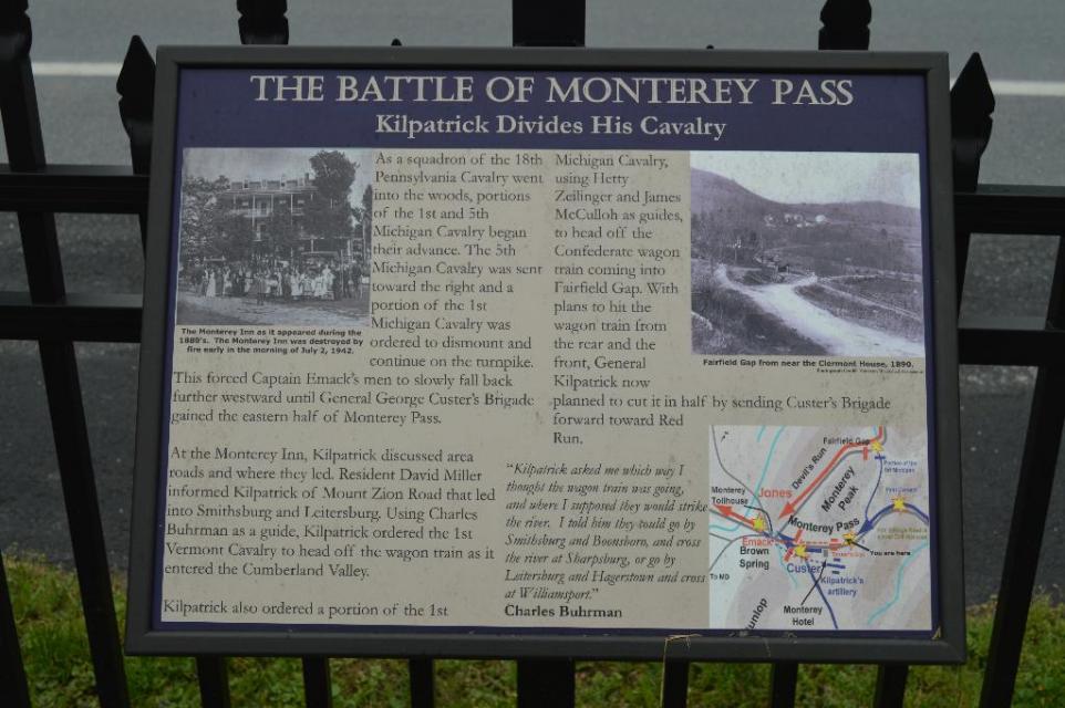
Photo Credits: [1] DOUGLAS MOWEN
Locationbig map
| UTM (WGS84 Datum) | 18S E 288432 N 4401680 |
|---|---|
| Decimal Degrees | 39.73878333, -77.46901667 |
| Degrees and Decimal Minutes | N 39° 44.327', W 77° 28.141' |
| Degrees, Minutes and Seconds | 39° 44' 19.6200" N, 77° 28' 8.4600" W |
| Driving Directions | Google Maps |
| Area Code(s) | 717 |
| Can be seen from road? | No |
| Is marker in the median? | No |
| Which side of the road? | Marker is on the right when traveling West |
| Closest Postal Address | At or near 14775 Charmian Rd, Blue Ridge Summit PA 17214, US |
| Alternative Maps | Google Maps, MapQuest, Bing Maps, Yahoo Maps, MSR Maps, OpenCycleMap, MyTopo Maps, OpenStreetMap |
Is this marker missing? Are the coordinates wrong? Do you have additional information that you would like to share with us? If so, check in.
Nearby Markersshow on map
Show me all markers in: Blue Ridge Summit, PA | Franklin County | 17214 | Pennsylvania | United States of America
Maintenance Issues
- Who or what organization placed the marker?
- This marker could use another picture or two.
Comments 0 comments