Inscription
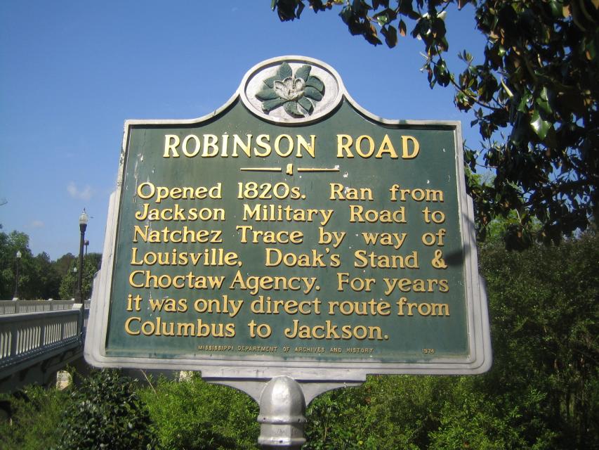
Opened 1820's. Ran from Jackson Military Road to Natchez Trace by way of Louisville, Doak's Stand & Choctaw Agency. For years it was only direct route from Columbus to Jackson.
Details
| HM Number | HMIOP |
|---|---|
| Tags | |
| Year Placed | 1974 |
| Placed By | Mississippi Department of Archives and History |
| Marker Condition | No reports yet |
| Date Added | Tuesday, October 14th, 2014 at 9:02pm PDT -07:00 |
Pictures
Locationbig map
| UTM (WGS84 Datum) | 16S E 366862 N 3706997 |
|---|---|
| Decimal Degrees | 33.49421667, -88.43320000 |
| Degrees and Decimal Minutes | N 33° 29.653', W 88° 25.992' |
| Degrees, Minutes and Seconds | 33° 29' 39.18" N, 88° 25' 59.52" W |
| Driving Directions | Google Maps |
| Area Code(s) | 662 |
| Closest Postal Address | At or near 424-544 MS-182, Columbus MS 39701, US |
| Alternative Maps | Google Maps, MapQuest, Bing Maps, Yahoo Maps, MSR Maps, OpenCycleMap, MyTopo Maps, OpenStreetMap |
Is this marker missing? Are the coordinates wrong? Do you have additional information that you would like to share with us? If so, check in.
Nearby Markersshow on map
Show me all markers in: Columbus, MS | Lowndes County | 39701 | Mississippi | United States of America
Maintenance Issues
- Is this marker part of a series?
- What historical period does the marker represent?
- What historical place does the marker represent?
- What type of marker is it?
- What class is the marker?
- What style is the marker?
- Does the marker have a number?
- This marker could use another picture or two.
- Can this marker be seen from the road?
- Is the marker in the median?
Comments 0 comments