Inscription
In 1916 Finnish immigrants constructed a hall near this site under the name of a literary association (Kirjallixuus Seura), forming a lending library. Although they brought their diet, language, and saunas with them, some old country beliefs were left behind. These people found it necessary to meet where they could study the social customs of their new country, challenge and question partisan politics, and reflect on new theological insights. At this cultural center were held language classes, meetings, athletic activities, wedding dances, funerals and programs with oratory, drama, poetry, vocal and instrumental music. Steaming kettles of coffee and the warmth of dignified waltzes, pulsating polkas and schottisches brought togetherness to these rugged individualists.
Life to them was involvement.
Life to them was involvement.
Details
| HM Number | HM59V |
|---|---|
| Tags | |
| Placed By | Descendants and friends of Finnish Settlers, Woodland Bicentennial Committee, Washington State Highways Commission, Washington State Parks and Recreation Commission, Cowlitz County Parks and Recreation Dept |
| Marker Condition |  3 out of 10 (1 reports) |
| Date Added | Monday, October 20th, 2014 at 1:20pm PDT -07:00 |
Pictures
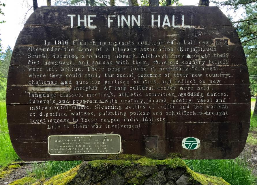


Photo Credits: [1] STEPHEN PERRY [2] STEPHEN PERRY [3] STEPHEN PERRY
Locationbig map
| UTM (WGS84 Datum) | 10T E 523798 N 5087825 |
|---|---|
| Decimal Degrees | 45.94358333, -122.69296667 |
| Degrees and Decimal Minutes | N 45° 56.615', W 122° 41.578' |
| Degrees, Minutes and Seconds | 45° 56' 36.90" N, 122° 41' 34.68" W |
| Driving Directions | Google Maps |
| Area Code(s) | 360 |
| Closest Postal Address | At or near 2885-2899 Old Lewis River Rd, Woodland WA 98674, US |
| Alternative Maps | Google Maps, MapQuest, Bing Maps, Yahoo Maps, MSR Maps, OpenCycleMap, MyTopo Maps, OpenStreetMap |
Is this marker missing? Are the coordinates wrong? Do you have additional information that you would like to share with us? If so, check in.
Nearby Markersshow on map
Show me all markers in: Woodland, WA | Cowlitz County | 98674 | Washington | United States of America
I Saw The Marker
Overall the sign is in poor condition...and has been vandalized, some of the writing removed. There is a nearby spring that floods the general area, turning the only drive/parking into a mudpit (at least in the early parts of summer). There's not much else to see...it's overgrown, with a decrepit bench and picnic table.
May 29, 2017 at 5:59pm PDT by skibumstevo
Maintenance Issues
- Is this marker part of a series?
- What historical period does the marker represent?
- What historical place does the marker represent?
- What type of marker is it?
- What class is the marker?
- What style is the marker?
- Does the marker have a number?
- What year was the marker erected?
- Can this marker be seen from the road?
- Is the marker in the median?
Comments 0 comments