Inscription
Matthias Harman, a Pennsylvania-born Virginian, became acquainted with Kentucky's Big Sandy River valley in the mid 1700s. Harman and some of his Virginia associates built a log cabin in the valley for hunting in 1755 in present-day Johnson County. In late 1787, Harman and others thought it was safe to return, so they established a permanent settlement in the Big Sandy Valley during the winter of 1787-88.
Harman's Station was located near the cabin built in 1755, at the junction of John's Creek and Louisa (Levisa) Fork of the Big Sandy River. This station became the first settlement in eastern Kentucky, and was completed by a small party from Walker's Creek, Virginia, guided by Mathias Harman. The arrival of Harman and his party opened up eastern Kentucky for settlement.
The settlers were briefly forced back to Virginia by persistent attacks by the Native Americans. They did, however, return in time to provide safety to the "frontier heroine" Jenny Wiley when she escaped Indian captivity in early 1790.
Details
| HM Number | HM1QBR |
|---|---|
| Tags | |
| Historical Period | 18th Century |
| Historical Place | Fort |
| Marker Type | Historic Structure |
| Marker Class | Historical Marker |
| Marker Style | Mounted |
| Marker Number | 736 |
| Marker Condition |  5 out of 10 (2 reports) |
| Date Added | Sunday, January 3rd, 2016 at 5:49pm PST -08:00 |
Pictures
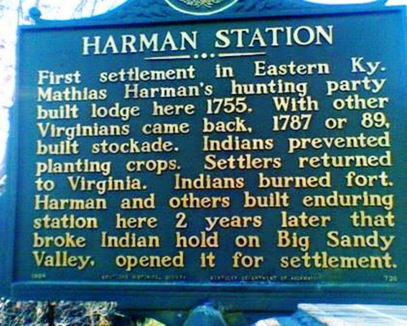
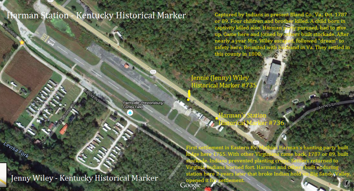
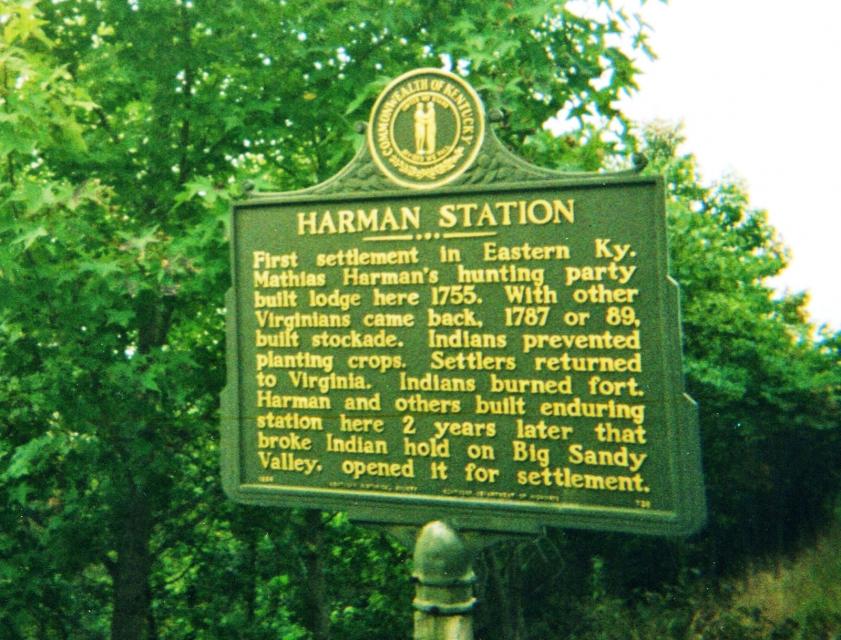
Photo Credits: [1] DARYL SKAGGS [2] DARYL SKAGGS [3] DARYL SKAGGS
Locationbig map
| Directions Information | Harman's Station is Kentucky historical marker #736 located 5 mi. S. of Paintsville, US 23, 460. |
|---|---|
| UTM (WGS84 Datum) | 44S E 659193 N 4182569 |
| Decimal Degrees | 37.74592900, -82.77904900 |
| Degrees and Decimal Minutes | N 37° 44.7557', W 82° 46.7429' |
| Degrees, Minutes and Seconds | 37° 44' 45.3444" N, 82° 46' 44.5764" W |
| Driving Directions | Google Maps |
| Area Code(s) | 606 |
| Can be seen from road? | Yes |
| Is marker in the median? | Yes |
| Closest Postal Address | At or near Airport Rd, Hagerhill KY 41222, US |
| Alternative Maps | Google Maps, MapQuest, Bing Maps, Yahoo Maps, MSR Maps, OpenCycleMap, MyTopo Maps, OpenStreetMap |
Is this marker missing? Are the coordinates wrong? Do you have additional information that you would like to share with us? If so, check in.
Nearby Markersshow on map
Show me all markers in: Hagerhill, KY | Johnson County | 41222 | Kentucky | United States of America
Jennie (Jenny) Wiley
Samuel May / Samuel May House Historical
The May Farm Historical
John C.C. Mayo
Morgan's Last Raid Historical
The Burns House / A Brief History of the Garfield Place Historical
County Named, 1799 Historical
Greenville R. Davidson, a War Memorial
Floyd County Veterans Memorial, a War Memorial
John Graham Historical
I Saw The Marker
Today, visited this marker for Mathias and the other marker for him in Dry Fork, Tazewell Co.
Jan 12, 2021 at 6:45am PST by chstudios
I Saw The Marker
Visiting my 6x great grandparents, Mathias and Lydia Skaggs Harman's old homeplace. I wasn't able to visit the cemetery because it's now gated off.
Jan 12, 2021 at 6:38am PST by chstudios
Comments 1 comments
Maintenance Issues
- Is this marker part of a series?
- Who or what organization placed the marker?
I posted this check-in comment on the wrong marker. Is there any way I can edit the above comment?