Inscription
93-18
Known as the "Village Cemetery", this was Berea's main burial ground from 1834 to the 1880s. However, in 1886, the Cleveland Stone Co. purchased quarries adjacent to the cemetery, where Coe Lake is today. Quarrying had already caused flooding and landslides in the area. Local stories say that the company operated too near to the edge of cemetery, causing a landslide in he northwest corner that exposed some graves. Worried families moved their loved ones' remains to other cemeteries, including those of five Civil War veterans. Pioneering families, 16 Civil War veterans, 3 mayors of Berea, several quarry owners, and many ordinary people still rest here. Of the original 589 burials 40% were children.(cont'd on other side)
The cemetery accepted burials into the 20th century, including one veteran of the Indian Wars and one of World War I, but it had fallen into disrepair and was used mainly for burial of indigents. One night in March 1930, vandals knocked over and broke many gravestones. In response, American Legion Post 91 repaired the stones. As the 21st century began, citizens recommitted themselves to honoring the cemetery. The City of Berea and many community groups helped fund preservation efforts, and American Legion Post 91 decorates veterans' graves. Baldwin Wallace College students and faculty have documented burial sites and volunteered many hours to repair broken tombstones.
Details
| HM Number | HM1LNM |
|---|---|
| Tags | |
| Historical Period | 19th Century |
| Historical Place | Cemetery |
| Marker Type | Memorial |
| Marker Class | Historical Marker |
| Marker Style | Free Standing |
| Marker Number | 93-18 |
| Year Placed | 2010 |
| Placed By | The Berea City Club, Inc. |
| Marker Condition | No reports yet |
| Date Added | Thursday, July 9th, 2015 at 7:31am PDT -07:00 |
Pictures
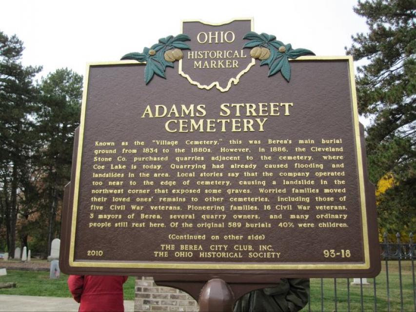
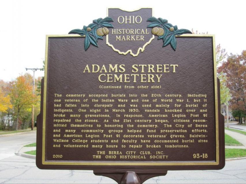
Photo Credits: [1] NIKKI SOPPELSA [2] NIKKI SOPPELSA
Locationbig map
| UTM (WGS84 Datum) | 17T E 428550 N 4579757 |
|---|---|
| Decimal Degrees | 41.36616000, -81.85430000 |
| Degrees and Decimal Minutes | N 41° 21.9696', W 81° 51.258' |
| Degrees, Minutes and Seconds | 41° 21' 58.1760" N, 81° 51' 15.4800" W |
| Driving Directions | Google Maps |
| Area Code(s) | 440, 216 |
| Can be seen from road? | Yes |
| Closest Postal Address | At or near 13-21 W Bridge St, Berea OH 44017, US |
| Alternative Maps | Google Maps, MapQuest, Bing Maps, Yahoo Maps, MSR Maps, OpenCycleMap, MyTopo Maps, OpenStreetMap |
Is this marker missing? Are the coordinates wrong? Do you have additional information that you would like to share with us? If so, check in.
Nearby Markersshow on map
Comments 2 comments
Maintenance Issues
- Is this marker part of a series?
- This marker could use another picture or two.
- Is the marker in the median?
Hi, thanks for the question. You may use the inscription, but in order to use the image you would need to acquire permission from the individual who owns the rights to the image and credit them. Images are submitted to this site from members, and are not owned by the website. For the inscription, it is recommended to credit the entity that is responsible for the marker itself (i.e. historical society, association, individual, etc.), but a mention of The Historical Marker Project website would be very much appreciated.
Mark Givens
Team Leader
Historical Marker Project
Does a member have permission to download and use the image and inscription in a book being written if this website is credited as the source?