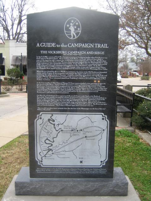
Inscription
The Vicksburg Campaign and Siege
— Brig. Gen. (Ret.) Parker Hills —
In April of 1861, rumors of Civil War became a reality at Charleston harbor when Fort Sumter was fired upon by Southern forces. Many leaders, both North and South, believed that a dash to capture the opposing side's capital city would bring a quick political end to the war. But Abraham Lincoln and Jefferson Davis were Western-born men and realized that the Mississippi River, king of the waterways, was a geographic key to victory. It was the River that meandered southward for 2,320 miles and delivered commerce and prosperity to the vast interior region. As the River bordered the state of Mississippi for over 600 strategic miles, it was only a matter of time before the Magnolia State would become a battleground for control of the Lower Mississippi River Valley.When the war closed the River to Northern commerce, the states of the Old Northwest demanded action, and by August all the manpower and treasure the Union could muster was aimed at reopening "the spinal column of America." A shallow-draft fleet of gunboats was rapidly built, and by mid-1862 the ironclad monsters roamed with impunity on the Western waters. Yet Vicksburg held fast, and the River remained closed from Vicksburg's wharf southward for 240 miles to Port Hudson, Louisiana.
In the first months of 1863, General Ulysses S. Grant masterminded a joint operation to open the last stretch of the River. Using multiple diversions to distract Confederate General John C. Pemberton, Grant achieved an unopposed river crossing at Bruinsburg, Mississippi, on April 30. He quickly overpowered a Southern force at the Battle of Port Gibson on May 1, and two days later entered Grand Gulf to establish a based to supply his campaign. Then, instead of marching directly north to Vicksburg, Grant surprised both friend and foe by marching northeast toward Pemberton's railroad line of communications.
On May 12, a Confederate force unsuccessfully struck Grant's right flank at the Battle of Raymond. Grant quickly changed his scheme of maneuver and pivoted east, capturing Jackson on May 14. The Federals then raced west toward Vicksburg and defeated Pemberton's army at the Battle of Champion Hill on May 16, and at Big Black Bridge on May 17. After attacks on Vicksburg on May 19 and 22 were beaten back, siege operations began. Almost two months later, Vicksburg and its army surrendered on July 4, and Port Hudson fell on July 9. The River was open and, as Lincoln declared, "The Father of Waters again flows unvexed to the sea."
"The sun did not shine more certainly than that the loss of the Mississippi was the loss of the war".
William Mansfield
Details
| HM Number | HM1LLL |
|---|---|
| Tags | |
| Marker Condition | No reports yet |
| Date Added | Tuesday, July 7th, 2015 at 10:02am PDT -07:00 |
Pictures

Locationbig map
| UTM (WGS84 Datum) | 15S E 742791 N 3572121 |
|---|---|
| Decimal Degrees | 32.25955000, -90.42265000 |
| Degrees and Decimal Minutes | N 32° 15.573', W 90° 25.359' |
| Degrees, Minutes and Seconds | 32° 15' 34.38" N, 90° 25' 21.54" W |
| Driving Directions | Google Maps |
| Area Code(s) | 601 |
| Which side of the road? | Marker is on the right when traveling South |
| Closest Postal Address | At or near 108 E Main St, Raymond MS 39154, US |
| Alternative Maps | Google Maps, MapQuest, Bing Maps, Yahoo Maps, MSR Maps, OpenCycleMap, MyTopo Maps, OpenStreetMap |
Is this marker missing? Are the coordinates wrong? Do you have additional information that you would like to share with us? If so, check in.
Nearby Markersshow on map
Maintenance Issues
- Is this marker part of a series?
- What historical period does the marker represent?
- What historical place does the marker represent?
- What type of marker is it?
- What class is the marker?
- What style is the marker?
- Does the marker have a number?
- What year was the marker erected?
- Who or what organization placed the marker?
- This marker could use another picture or two.
- Can this marker be seen from the road?
- Is the marker in the median?
Comments 0 comments