Inscription
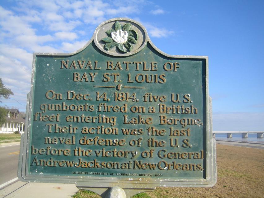
On Dec. 14, 1814, five U.S. gunboats fired on a British fleet entering Lake Borgne. Their action was the last naval defense of the U.S. before the victory of General Andrew Jackson at New Orleans.
Details
| HM Number | HM1HWM |
|---|---|
| Tags | |
| Year Placed | 1993 |
| Placed By | Mississippi Department of Archives and History |
| Marker Condition | No reports yet |
| Date Added | Tuesday, November 18th, 2014 at 1:02pm PST -08:00 |
Pictures
Locationbig map
| UTM (WGS84 Datum) | 16R E 276557 N 3355838 |
|---|---|
| Decimal Degrees | 30.31373333, -89.32375000 |
| Degrees and Decimal Minutes | N 30° 18.824', W 89° 19.425' |
| Degrees, Minutes and Seconds | 30° 18' 49.44" N, 89° 19' 25.5" W |
| Driving Directions | Google Maps |
| Area Code(s) | 228 |
| Which side of the road? | Marker is on the right when traveling North |
| Closest Postal Address | At or near 400-406 N Beach Blvd, Bay St. Louis MS 39520, US |
| Alternative Maps | Google Maps, MapQuest, Bing Maps, Yahoo Maps, MSR Maps, OpenCycleMap, MyTopo Maps, OpenStreetMap |
Is this marker missing? Are the coordinates wrong? Do you have additional information that you would like to share with us? If so, check in.
Nearby Markersshow on map
Show me all markers in: Bay St. Louis, MS | Hancock County | 39520 | Mississippi | United States of America
Maintenance Issues
- Is this marker part of a series?
- What historical period does the marker represent?
- What historical place does the marker represent?
- What type of marker is it?
- What class is the marker?
- What style is the marker?
- Does the marker have a number?
- This marker could use another picture or two.
- Can this marker be seen from the road?
- Is the marker in the median?
Comments 0 comments