Inscription
The tiny cottage known as "The Abbey" was built by the 19th century poet and environmentalist Joaquin Miller as part of a inspirational artists' retreat. He purchased 70 grassy acres, parcel-by-parcel, in "The Hights" above the "City of the Oaks" in 1886 and erected monuments, structures for his mother and daughter, and coordinated the planting of 75,000 trees - Monterey pine, Monterey cypress, olive and eucalyptus.
Below the photograph of Joaquin Miller on the upper-right.
"The Abbey was a frame building consisting at first of a single small room with a porch. The roof was a high shingled peak, and there was no ceiling, for the rafters supporting the roof had been left bare. Visitors often said that the room looked like an unfinished museum. The walls were made of rough boards, hung with hides, bear claws, sheep horns, antlers, Mexican saddles, bows and arrows and weapons of all sort. Wherever there was a vacant spot, Joaquin had tacked up photographs of actresses and of himself, magazine and newspaper clippings concerning himself, and some original drawings that he had done as illustration for his poetry."
Excerpt from the book Splendid Poseur: Joaquin Miller, American Poet, M. Marion Marberry, Crowell, 1953
Details
| HM Number | HM1D0L |
|---|---|
| Tags | |
| Year Placed | 2010 |
| Placed By | City of Oakland |
| Marker Condition |  8 out of 10 (2 reports) |
| Date Added | Wednesday, September 3rd, 2014 at 8:57am PDT -07:00 |
Pictures

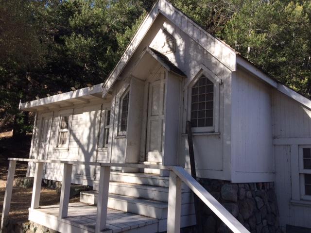

Photo Credits: [1] ELLEN KOMP [2] ELLEN KOMP [3] ELLEN KOMP
Locationbig map
| UTM (WGS84 Datum) | 10S E 571030 N 4185107 |
|---|---|
| Decimal Degrees | 37.81060000, -122.19305000 |
| Degrees and Decimal Minutes | N 37° 48.636', W 122° 11.583' |
| Degrees, Minutes and Seconds | 37° 48' 38.16" N, 122° 11' 34.98" W |
| Driving Directions | Google Maps |
| Area Code(s) | 510 |
| Closest Postal Address | At or near 134 N Royal St, Oakland CA 94602, US |
| Alternative Maps | Google Maps, MapQuest, Bing Maps, Yahoo Maps, MSR Maps, OpenCycleMap, MyTopo Maps, OpenStreetMap |
Is this marker missing? Are the coordinates wrong? Do you have additional information that you would like to share with us? If so, check in.
Nearby Markersshow on map
Show me all markers in: Oakland, CA | Alameda County | 94602 | California | United States of America
I Saw The Marker
The house is boarded up but in good shape. There is also a Historical Marker on the site, which is next to a statue of Miller on horseback, a shed with a fireplace where he kept artifacts, and a WPA built amphitheater with elaborate stone steps and pathways.
Sep 28, 2017 at 9:46am PDT by chrishend
Maintenance Issues
- Is this marker part of a series?
- What historical period does the marker represent?
- What historical place does the marker represent?
- What type of marker is it?
- What class is the marker?
- What style is the marker?
- Does the marker have a number?
- Can this marker be seen from the road?
- Is the marker in the median?
Comments 0 comments