Inscription
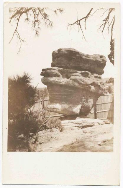
A Privately-Owned Balanced Rock
In the 1890s, photographer Paul Goerke shrewdly purchased the land around Balanced Rock. Goerke and his son, Curt, snapped photos of tourists for .25 cents each. The Goerkes then developed the plates in their shop at Steamboat Rock.
In the 1890s, photographer Paul Goerke shrewdly purchased the land around Balanced Rock. Goerke and his son, Curt, snapped photos of tourists for .25 cents each. The Goerkes then developed the plates in their shop at Steamboat Rock.
Thousands Have Their Photos Taken
Originally the Goerkes let people view Balanced Rock for free. They made money by charging for portraits and in later years selling photographic supplies. They even furnished trusty burros as props.
From Private Business to Public Park
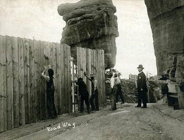
Once personal cameras became more available, people started taking their own photos. To generate income, Curt Goerke built a wooden fence around Balanced Rock and charged .25 cents admission. When the City of Colorado Springs purchased the Goerke property in 1932, a large crowd cheered the dismantling of the wall.
(Picture captions: Curt Goerke set his large camera at an exact spot where he left it each day while taking photographs of the tourists posing on donkeys he supplied. Goerke operated a lucrative lunch counter adjacent to Steamboat Rock and created picnic grounds complete with fire pits for the thousands of tourists who visited each summer. As early as 1909 the City of Manitou Springs disputed the Goerke Family's control over public access on the road leading to and from Balanced Rock.)
Details
| HM Number | HMUXL |
|---|---|
| Tags | |
| Marker Condition | No reports yet |
| Date Added | Sunday, October 19th, 2014 at 9:58pm PDT -07:00 |
Pictures

Locationbig map
| UTM (WGS84 Datum) | 13S E 508904 N 4301793 |
|---|---|
| Decimal Degrees | 38.86493333, -104.89736667 |
| Degrees and Decimal Minutes | N 38° 51.896', W 104° 53.842' |
| Degrees, Minutes and Seconds | 38° 51' 53.76" N, 104° 53' 50.52" W |
| Driving Directions | Google Maps |
| Area Code(s) | 719 |
| Closest Postal Address | At or near 532-572 Garden Dr, Colorado Springs CO 80904, US |
| Alternative Maps | Google Maps, MapQuest, Bing Maps, Yahoo Maps, MSR Maps, OpenCycleMap, MyTopo Maps, OpenStreetMap |
Is this marker missing? Are the coordinates wrong? Do you have additional information that you would like to share with us? If so, check in.
Nearby Markersshow on map
Maintenance Issues
- Is this marker part of a series?
- What historical period does the marker represent?
- What historical place does the marker represent?
- What type of marker is it?
- What class is the marker?
- What style is the marker?
- Does the marker have a number?
- What year was the marker erected?
- Who or what organization placed the marker?
- Can this marker be seen from the road?
- Is the marker in the median?
Comments 0 comments