Inscription
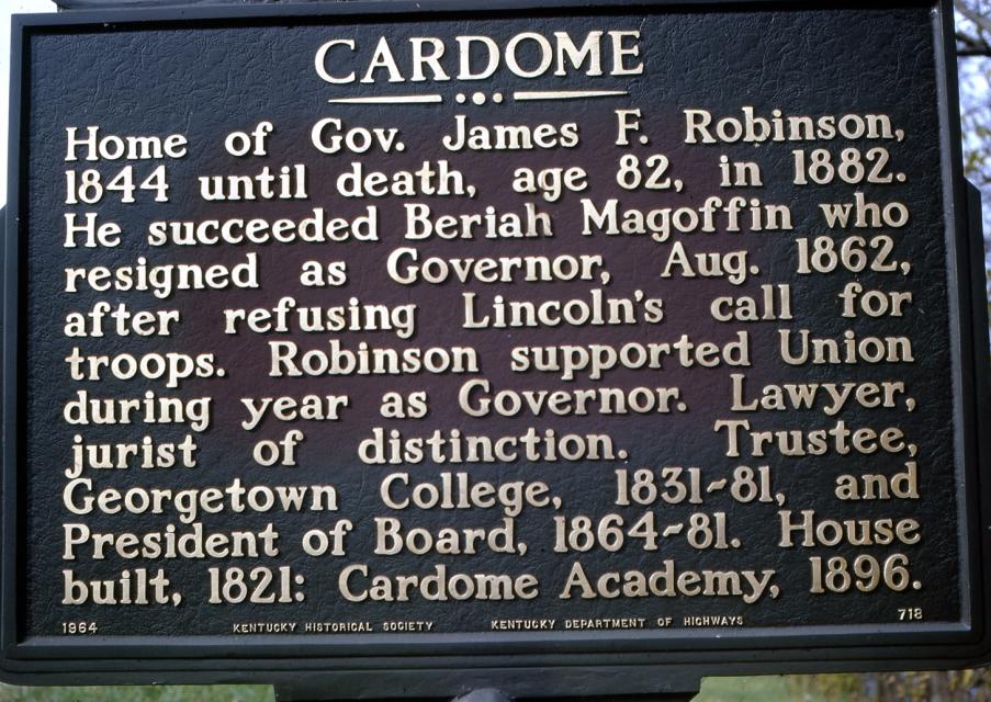
Home of Governor James F. Robinson, 1844 until death, age 82, in 1882. He succeeded Beriah Magoffin who resigned as Governor, August 1862, after refusing Lincoln's call for troops. Robinson supported Union during year as Governor. Lawyer, jurist of distinction. Trustee, Georgetown College, 1831-81, and President of Board, 1864-81. House built, 1821: Cardome Academy, 1896.
Details
| HM Number | HM1LE2 |
|---|---|
| Tags | |
| Marker Number | 718 |
| Year Placed | 1964 |
| Placed By | Kentucky Historical Society, Kentucky Department of Highways |
| Marker Condition | No reports yet |
| Date Added | Monday, June 29th, 2015 at 10:03am PDT -07:00 |
Pictures
Locationbig map
| UTM (WGS84 Datum) | 16S E 713035 N 4233330 |
|---|---|
| Decimal Degrees | 38.22275000, -84.56635000 |
| Degrees and Decimal Minutes | N 38° 13.365', W 84° 33.981' |
| Degrees, Minutes and Seconds | 38° 13' 21.9" N, 84° 33' 58.86" W |
| Driving Directions | Google Maps |
| Area Code(s) | 502, 859 |
| Closest Postal Address | At or near 780-818 N Broadway St, Georgetown KY 40324, US |
| Alternative Maps | Google Maps, MapQuest, Bing Maps, Yahoo Maps, MSR Maps, OpenCycleMap, MyTopo Maps, OpenStreetMap |
Is this marker missing? Are the coordinates wrong? Do you have additional information that you would like to share with us? If so, check in.
Nearby Markersshow on map
Hemp in Scott County / Hemp in Kentucky
First Baptist Church
Payne-Desha House / Joseph Desha (1768-1842)
Royal Spring
Scott County Courthouse / Goebel Trial Here
Scott County, 1792
Gen. Basil W. Duke, C.S.A. - Basil W. Duke (1838-1916)
Remember the Raisin!
The Beginnings of George Town
Scott County Revolutionary War Memorial
Maintenance Issues
- Is this marker part of a series?
- What historical period does the marker represent?
- What historical place does the marker represent?
- What type of marker is it?
- What class is the marker?
- What style is the marker?
- This marker could use another picture or two.
- Can this marker be seen from the road?
- Is the marker in the median?
Comments 0 comments